From the Thorley
Archives
Thorley's 1845 Tithe Map
Two years ago I was given
a small, red notebook containing 'some information about Thorley that might
be of interest to you'. The book had belonged to Miss D. Sortwell. She had painstakingly
transcribed the complete record of details of the contents of the 1845 Thorley
Tithe Award. The Thorley Parish records, stored at the Hertford Archive and
Local Studies Office (HALS), listed the original written Award but they couldn't
find its accompanying Tithe Map. The Public Record Office at Kew also had an
original copy of our Tithe Apportionments (written details) but no map. Last
year I enlisted the help of Wally Wright (Bishop's Stortford historian) and
we were given permission to search for the map at HALS. We eventually tracked
it down, filed under a different reference number, and we were allowed to photograph
it for the Thorley archives.
Since the 8th century it
was a legal obligation that landowners had to hand over a tenth of the produce
of their land for the maintenance of the chancel of the church and provision
of church worship. Great tithes from corn and hay went to the Rector who was
responsible for this provision. Where an institution was responsible for the
church or chapel then a Vicar was appointed to receive the small tithes from
livestock, wool and non-cereal crops. After the Reformation Henry VIII 'sold'
monastic tithe rights to lay people. Early in the 19th century the Nonconformist
churches began to oppose this practice of the Established church and a Commutation
Act was passed in 1836. A Tithe Commission appointed surveyors who produced
large-scale maps and schedules for every parish between 1836 and 1852. Subsequent
Tithe Acts meant that tithe charges gradually disappeared - the last ones were
redeemed in 1996!
The written tithe schedule
lists the names of owners and occupiers of the land together with names, acreage,
state of cultivation of each field and the assessed rent charge to the church.
An accompanying tithe map contained reference numbers for each field and property
that matched the written schedule. The two documents were often bound together.
For family history and local history researchers such documents provide a rich
and accurate source of material. Individual land holdings can be located and
linked to the earliest census returns of 1841 and 1851. The map is especially
useful in researching the history of the landscape and the significance of field
names.
By transferring Miss Sortwell's
handwritten notes to an Excel spreadsheet it has been possible to analyse the
extent of the ownership and occupation of Thorley's landholdings. In 1845 Lord
Ellenborough owned Thorley Hall and Thorley Wash farms covering nearly 500 acres
and was assessed at £164=4s=6p. George Frere at Twyford House was the second
largest landowner with 180 acres. There were ten other landowners with between
20 and 100 acres, including the Rector with 49 acres.
The tithe map provides
an intriguing insight into the distribution of fields, their shapes and sizes
and the derivation of field names. Thorley parish in 1845 extended from the
River Stort in the east, up the valley side to the church and manor house in
the middle of the parish and then on to the higher ground towards the road to
Much Hadham. The fields in the river valley were meadows for grass and hay crops.
They are small in size, and have names such as Slumbers Mead, Lucky Piece, The
Bottoms and Moors. Rising up the valley, from the main road behind Thorley Street,
are the most regular sized fields in Thorley with straight hedge lines and right
angled corners. These have commonplace names such as Upper and Lower Thorley
Fields, Great Wood Field and Great Pond Field. There is a possibility that these
field patterns and names were the result of the Enclosure Acts that, from the
Middle Ages, consolidated open field systems and common land to make farming
more efficient. On the 1845 map common land is still in existence in the North
West quarter of the parish. This is the area where St Michaels Mead housing
now exists. Remnants of medieval strip farming where villagers or commoners
farmed furlongs of unfenced land is still obvious in an area of small fields,
without individual names, but marked collectively as Thorley Common.
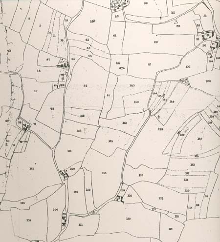
A Section of the 1845 Thorley
Tithe Map
showing remnants of
medieval strip farming in the field boundaries.
Present day St Michaels Mead
covers the right half of the map whilst Butlers Hall Farm is in the
top left quadrant.
This part of the parish was known
as Thorley Common.
|
|
Bill Hardy
February 2006
From the Archives