 |
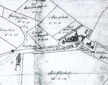
An Annotated Extract from the Thorley Tithe Map
of 1845
St James the Great Church and the St Barnabas Centre are in the top centre section
St James the Great Church and the St Barnabas Centre are in the top centre section
From the Thorley Archives
Thorley Field Names
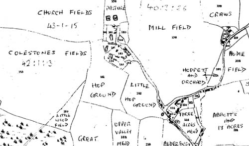
When a name was chosen for the road linking the roundabout at the top of Whittington Way to the new roundabout on St James Way, the District Council named it after the field that the lane bordered. I suspect that that the name was transmitted orally, perhaps by phone, as the original blue sign read Aubrey Way. This was later corrected to its present spelling of Obrey Way. An exasperated Thorley Parish councillor has since told me that they intended it to be either Alberry Way (from a 1672 estate map) or even Alderbury Way (from the 1845 Tithe Map).
This graphically illustrates how names of places and people have historically been transmitted by word of mouth, giving rise to a variety of spellings. By comparing ancient and modern maps of the parish of Thorley it is interesting to note how some field names have changed in spelling, how many have not, and how the fields were given their names in the first place.
Examples of spelling changes
· The large field to the south east of the church was Coldson in 1672, Colestones
in 1845 and is Coaching in 2005.
· The roads to the north of the cricket field were in Southwickes in 1672, Sedgewicks
in 1845 and, before Thorley estate was built, in Sudricks.
Existing field names
Local land owner David Tinney, when amalgamating fields for increased farming
efficiency, has been keen to keep historical names.
· Barn Field (to the north west of Moor Hall) now includes 'Fourteen Acres'
field.
· The fields to the south of the eastern end of St James Way are still Pond
Field and Wood Field as they were in 1672.
· Henley Hern is a consolidation of fields behind Thorley Wash farm named after
the stream that borders the field. On the 1672 map Henly Hern was the name of
the spring that originated at the top of the present day field.
· Park Field, situated to the north of the road to Much Hadham from the roundabout
at the northern end of St. James Way, is the result of Upper Park and Further
Park Fields.
|
An Annotated Extract from the Thorley Tithe Map
of 1845
St James the Great Church and the St Barnabas Centre are in the top centre section |
To view the Lord Ellenborough Estate Map of 1825 click here.
|
An Extract from the Thorley Hall Estate Map of
1672
Showing Pictorial Illustrations of Thorley Hall, St Barnabas Barn and the Church |
|
Derivation of field names
· To the north of the St. Barnabas Centre was Mill Field a large 40 acre field.
Being on a high point in the parish it probably contained a windmill at sometime.
· Abbott's Field was glebe, or church, land adjacent to the Victorian vicarage,
sold by the church within living memory and has since given its name to Abbotts
Way.
· Church Fields is now, and was in 1672, a 40 acre field to the south of St
James the Great church.
· One could speculate that Slumbers Mead, opposite the 'new' roundabout at Thorley
Wash, acquired its name from the rich, and no doubt soporific, wild flower hay
that it produced for the many animals of Thorley Wash Farm.
· Some field names obviously derived from crop names such as Plum Field, Potato
Field and Broccoli Field - all on Rumbolds Farm. South east of the St Barnabas
Centre are 16 acres made up of Hop Ground and Little Hop Ground and where the
Twyford estate is now built used to be 10 acre Vine Yard field.
· Other names are quite commonplace - Six Acres (Rumbolds Farm), Long Field
(beyond Park Field) and The Valley (between the Coach and Horses and old Thorley
School / Scout Hut).
· The derivation of other names has been lost in the 'mists of time' - Wynches
(next to Church Field), Craws (behind Premier Court Home) and Hempstalls (to
the south west of Whittington Way)
The size, shape and patterns of Thorley's farms and fields also provides scope for a fascinating study and the subject no doubt for a further 'In Touch' church magazine article.
Bill Hardy
May 2005